Nippon No Haikyo, probably the most famous Japanese book about urban exploration / haikyo since it was recommended plenty of times by both Japanese and foreign blogs because of its huge amount of maps, recommended Yashima as one of the top abandoned places in West Japan. In my opinion Nippon No Haikyo is vastly overrated – while some maps are quite detailed others are completely useless. Even more so since an estimated 50% of the places (at least on the West Japan list) are either demolished or completely trashed by now. At the same time some of the best haikyo locations, like *Nara Dreamland*, are missing completely. But I guess you’ll get what you pay for: a 4 year old book about a topic that can change within a week or two. Especially in Japan, where old buildings are replaced by parking lots while you are on vacation. (It actually happened in my neighborhood…)
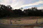
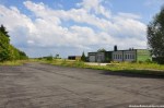
So whenever I visit a location described in Nippon No Haikyo I’m prepared for the worst, just in case. Which was a good thing in the case of Yashima – more than half of the buildings that were responsible for the praisal are gone now; four, to be specific. All that was left of them: 3 leveled building grounds, ready for new construction to begin. Construction that most likely won’t happen.
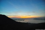
Yashima (屋島, roof island) has attracted people for centuries. The famous temple Yashima-ji on top of the mountain, founded as a Ritsu school temple in 754 by Ganjin (a.k.a. Jianzhen, 688–763), is the 84th stop of the Shikoku 88 temple pilgrimage. On March 22nd 1185 the Battle of Yashima took place in the waters around Yashima, resulting in one more defeat for the Taira, who owned a castle on top of the mountain. (Which is being reconstructed as I write these lines…) The whole story was later made popular in an epic poem called “The Tale of the Heike” (平家物語, Heike Monogatari).
A famous temple, stunning views of the Seto Inland Sea, a historical battle. What else do you need to attract tourists? Right, an aquarium! The Yashima Mountaintop Aquarium (屋島山上水族館, Yashima Sanjo Suizokukan) was opened in 1969 and reopened as the New Yashima Aquarium (新屋島水族館, Shin Yashima Suizokukan) in 2006. In-between some (not so) smart businessmen took advantage of the Japanese asset price bubble (1986 to 1991) to build some rather big hotels on Yashima, creating way more beds on the 300 meter high mountain than necessary. Because let’s be honest: Yashima is a daytrip location, not a place to stay overnight. (Heck, I made it a daytrip although I live in Osaka!) Around the turn of the millennium most of those new hotels were already forced to close, only a few smaller ryokan north of Yashima Temple survived. It seems like the closed hotels were still standing there when Nippon No Haikyo was written in 2007, maybe for two or three more years – when I visited in late 2011 most of them were gone… The Lost Ruins of Mount Yashima.
(I used this posting for a big update of my *Map of Demolished Places in Japan* – it’s really worth a look!)
Archive for November, 2011
The Lost Ruins Of Mount Yashima
Posted in Demolished, Haikyo, Hiking, Hotel / Ryokan, House, Japan, Kagawa, Map, Restaurant, Sacred Site, Shikoku, Urbex, Visited in 2011 on 2011/11/28| 2 Comments »


Sembach Air Base
Posted in Abandoned, Airport, Demolished, Depot, Europe, Fire Station, Germany, House, Military, Rhineland-Palatinate, Transportation, Urbex, Video, Visited in 2011 on 2011/11/17| 58 Comments »
The now abandoned Sembach Air Base has quite a long history. The location was first used as an airfield after World War I by the French occupation troops in 1919 with 10 sheet-iron barracks and 26 wooden hangars. When France retreated from Germany in 1930 the air base was abandoned on June 15th and the land was returned to farmers who used it as a hay field. (The area around Sembach is very rural and agriculture is an important economic factor till this very day.)
In preparation of World War II the Nazi-German Luftwaffe deemed the area proper to build a fighter base and claimed the land in early 1940, but gave it back to the owners in June of 1940 after France was conquered in a blitzkrieg now known as the “Battle of France”.
After the defeat of Nazi-Germany in May of 1945 Sembach was part of the French occupational zone. In April of 1951 German surveyors along with French officers were looking for suitable locations for air bases. The Cold War had begun a few years prior and both the NATO and the Warsaw Pact armed themselves at a remarkable speed. The NATO’s lack of air fields suitable for modern jets made it necessary to build new military airports – so the French authorities began with the construction of a hard surface airfield in June of 1951, much to the protest of local farmers, who demonstrated in Mainz, the capital of Rhineland-Palatinate, without much success. On September 1st the United States took over the construction site, naming it Sembach Air Auxiliary Field, and pushed hard to finish the base – completing the 8500 foot concrete runway by the end of the month working round the clock using nighttime illumination. The rest of the airfield (tower, hangars, repair shops, storages and other buildings) were built during the winter. Local protests rose again when plans for the construction of barracks and office buildings surfaced in April of 1952 – this time with a little bit more success: Instead of using valuable farm land the new buildings were constructed on a sandy area with little agricultural value about 1.5 kilometers away from the airfield (Heuberg). Everybody was happy and after another year of construction the American flag was finally raised at the base now known as Sembach Air Base on July 8th 1953, when a RB-26 Invader arrived from Shaw Air Force Base in South Carolina. It was part of the 66th Tactical Reconnaissance Wing, the first of many units to be stationed in Sembach.
40 years after Sembach Air Base was opened protests rose again – this time because the Americans announced plans that the base will only be used as a substation of Ramstein Air Base; a huge economical setback for the town and nearby cities, directly (German civilian employees at the base) and indirectly (soldiers spending money in the area). The airfield was returned to German control two years later on March 30th 1995, the installations in Heuberg were renamed Sembach Annex. In summer of 1998 the demolition of the base began, the runway being the first “victim” of this process. Since then most of the buildings on the former air base have been demolished – but not all of them, at least not by the time Gil and I arrived at the location.
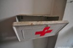
After the *Deportation Prison Birkhausen* and the *USAREUR Communication Facility Lohnsfeld* turned out to be quick stops we decided to tackle another big one and drove to Sembach to have a look at what was left of the air base. First we went to the western part and found some half-underground bunkers, inaccessible of course. Next was a small office building (?) that looked like it was made of corrugated cardboard. Quite interesting was the former Fire Station, part of the Fire and Emergency Service. I was rather surprised by the coloring of the toilets – white and pink. Seriously? The restrooms of the fire department on a US Air Force base were pink?
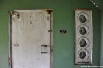
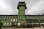
In the afternoon, when we left the fire station, the weather started to turn drastically. The sunshine was gone and dark grey clouds approached quickly. While we were making our way to the abandoned tower the wind sped up massively – to my favor as I should find out minutes later. I just finished shooting the tower building when a wall of rain came closer quickly and before I had the chance to take shelter it poured liked I was standing in the shower; a first class cloudburst. At that time I was close to the eastern wall of the tower, so I pressed myself against the high wall while the wind was blowing so hard that it actually blew the rain over my head. About 15 minutes I was standing there, hoping for the wind to continue and the rain to stop. When the heavy rain turned into light drizzling I started to look for Gil, who found shelter in a nearby building I assumed was inaccessible. That building was boarded up (almost) completely and its massive walls made me wonder right away what it was used for. Sadly it was pretty much empty, nevertheless we found some interesting items – a sleeping bag and other signs of a homeless person being there for a while, a perforated cardboard character and some documents with rather sensitive information; like special travel orders, granting individuals the permission to hand-carry a M16 rifle. I have no clue how those documents escaped the shredder, but I guess I better refrain from posting photos since each sheet of paper contained several names including ranks and addresses…
Going on an exploration trip with Gil was absolutely fantastic (thanks, man!). While the first two locations were quite disappointing from an urbex point of view Sembach Air Base made up for it big time. It was the first US military base I was able to explore (yes, I went to a second one, so stayed tuned!) and I had a blast – no pun intended. The locations in Germany differ quite a bit from the places I usually get to see in Japan, so I really enjoyed this refreshing experience!
Addendum 2013-08-27: If you liked this article, check out the one about the nearby *Hochspeyer Munitions Storage*!
(If you don’t want to miss the latest article you can *like Abandoned Kansai on Facebook* and *follow this blog on Twitter* – and of course there is the *video channel on Youtube*…)


USAREUR Communication Facility Lohnsfeld
Posted in Communications, Demolished, Europe, Germany, Military, Rhineland-Palatinate, Urbex, Visited in 2011 on 2011/11/11| 54 Comments »
Urbex in France? Urbex in Luxembourg? Urbex in Belgium? Or urbex in Germany? That was the big question after our visit to the *Deportation Prison Birkhausen* was a unexpectedly short one – where should we continue our urban exploration day trip? There were plenty of options, but since Kaiserslautern (a.k.a. K-Town, especially amongst American military) was rather close we decided to continue our explorations there. The next place to visit: The USAREUR Communication Facility Lohnsfeld.
Very little is know about this former US military installment. The Energy Engineering Analysis Programm (EEAP) from August 1986 prepared for the Department of the Army, European Division, Corps of Engineers described it as “Located at Lohnsfeld, the station consists of a barracks and receiver building”. The facility was open from at least 1953 and on 1998-09-03 the U.S. Department of Defense announced that the Lohnsfeld Communications Station will be returned to the host nation, in this case Germany. It seems like my home country didn’t have any use for it and left the comm fac in the middle of nowhere abandoned, until… it was demolished in October of 2007. Which I found out about after I went there with my old buddy Gil – after we drove through the middle of nowhere for maybe half an hour, including dirt roads along some fields and an airport for model aircrafts. So maybe urbex in France, urbex in Luxembourg or even urbex in Belgium would have been a better alternative. (The place I really wanted to go, Villa Viktoriastift, one of the few abandoned mansions in Germany, became inaccessible a week prior when the new owner of the place was fed up by geocachers swarming the place – so he informed the police, threatened to sue some people (including the person who put the cache there!) and hired security…) Luckily Lohnsfeld wasn’t our last stop on our trip to Palatinate – and the last location made up big time to the first two less successful ones…


Abandoned Kansai on Facebook
-
Join 5,100 other subscribers
Pages
Archives
Categories
Recent Comments
Florian / Abandoned… on Sakura Sports Park Gred Cz on Sakura Sports Park Florian / Abandoned… on Mie Minshuku Florian / Abandoned… on Mie Minshuku Florian / Abandoned… on Sakura Car Shop Florian / Abandoned… on Sakura Car Shop Ja Ni on Hahn Air Base (Flughafen … Gred Cz on Sakura Car Shop Sue on Sakura Car Shop Gred Cz on Mie Minshuku
