All abandoned: Chernobyl / Pripyat, Nara Dreamland, Anti-Zombie Fortress, Japanese Sex Museum – and many, many more! Plus: North Korea Special – 2 trips, 16 days / 14 nights! As seen on CNN…
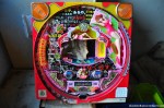
In mid-December of 2011 the North Korean “Dear Leader” Kim Jong-il died coincidentally at around the same time I wrote my article about the abandoned *K-1 Pachinko Parlor* (about 30 to 40 % of Japanese pachinko parlors have ties to North Korea) – and the whole North Korea thing came back to my mind. You know, my urge to visit North Korea being limited by my unwillingness to support the system by spending money on it.
I’ve been growing up in a divided country myself (Germany) and I’ve been fascinated by dystopian literature and movies as well as the aesthetics of run down architecture for about two decades, so I guess a certain interest in North Korea was only natural – especially when living in a neighboring country, Japan, for more than 5 years now.
Exploring abandoned buildings in North Korea will most likely be off-limits for quite a while; unless you are North Korean, of course, but I guess then you have other and more serious problems…
So what’s the next best thing when exploring abandoned North Korean buildings in North Koreaisn’t an option and pachinko parlors are too obscure? Right, you look for abandoned institutions once run by North Koreans close to where you live. While the Republic of Korea (= South Korea / 대한민국) has one embassy and nine consulates in Japan, the Democratic People’s Republic of Korea (= North Korea / 조선민주주의인민공화국 / 朝鮮民主主義人民共和國) doesn’t have any of those institutions, let alone abandoned ones. But since Koreans are by far the biggest minority in Japan (in 2005 more than 900,000 Koreans lived in Japan, only 285,000 of them naturalized Japanese citizens – most of the rest are Zainichi Koreans, Koreans with a permanent residency) they are pretty well organized to get their interest represented. Of the 610.000 Zainichi Koreans about 65% are members of the Mindan (Korean Residents Union of Japan / 민단) with ties to South Korea, while another 25% are members of the Chongryon (General Association of Korean Residents in Japan / 총련 / 總聯) with strong ties to North Korea. Interestingly enough there is a Japanese group called Zaitokukai (在日特権を許さない市民の会, Citizens against Special Privilege of Zainichi) who opposes both groups – and sometimes even more: On October 31st 2009 some members protested foreigners in Halloween costumes with a sign stating “This is not a white country”. Whenever you thought you’ve seen and heard it all…
But let’s get back to the Chongryon. In addition to offering support and various services to their members (including issuing North Korean passports) the Chongryon not only controls a serious chunk of the Japanese pachinko money, it also runs about 140 schools (朝鮮学校 / 조선학교), kindergartens and a university in Japan. While it is said that all the classes and conversations at those schools are conducted in Korean I am not 100% sure about that since the few leftover books I saw at the abandoned school I visited were (partly) in Japanese. So, yes, some of the North Korean schools in Japan are deserted now. Which isn’t a surprise given the fact that the number of students enrolled in those schools went down from 46,000 in the 1970s to about 15,000 in 2004.
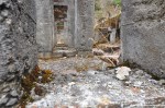
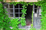
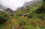
The abandoned North Korean school in Gifu prefecture I visited rather spontaneously in late December of 2011 must have been victim of that loss of interest. Half an hour by foot away from the next train station the school was located on top of a small hill, overseeing the surrounding countryside. With about half a dozen classrooms plus special rooms for sports, physics, chemistry and music it’s quite easy to understand why this Chongryon institution was one of the first candidates to become a modern ruin. Opened in 1975 it closed in 1998 already – its students being transferred to another Chongryon school in the suburbs of Nagoya; 20 minutes away by train, but closer to a railway station.
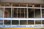
Exploring a North Korean School on Japanese ground was nothing like I expected. The school looked nothing like I expected. No North Korean flags, no propaganda material, no socialist style architecture. Quite the opposite. The layout of the school was full of nooks and crannies, its level of decay reminded me of *my trip to Pripyat and Chernobyl*. I was actually so fascinated by it that I walked around for maybe half an hour to see every last bit of it without taking a photo – and then I took a 19 minute long video. Usually I try to break up buildings by floors or other units, but this school felt so organic I had to turn into a poor man’s Michael Ballhaus and film the whole abandoned and quite seriously vandalized building in one shot. Always having Sting’s “Russians” in the back of my mind.
Do the North Koreans love their children, too? Having the physical distance of living in Europe, the States or Australia the problem might not sound so serious and North Korea might appear as that wacky little state with its funny looking leaders, but living in a neighboring country there are quite a few people here that are worried about what will happen in the upcoming weeks and months – and given the fact that South Korea and the States placed their troops under high alert I guess there is a serious number of people who are having serious thoughts about that “bonsai Cold War”. Personally I’m not much of a worrier. I actually still like cracking jokes about North Korea being reunited with South Korea and East Korea. (East Korea being Japan, based on a theory that around 300 AD a Korean cavalry army conquered Japan, and therefore the rulers of Japan are actually of Korean descent till this very day. Especially Japanese people don’t think my quirky humor is funny…)
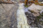
I have no doubts the North Koreans love their children, too – sadly this deserted school was no indicator. I wish there would have been more signs that the school actually was a North Korean school. I found a couple of washed-out pieces of paper showing past school festivities, describing them in Korean, having the cliché level of formality and stiffness you would expect of events like that. In the lobby was a smashed “World Atlas” with several destroyed clocks on top – interestingly enough the people in charge included Moscow, but chose London over (East) Berlin; Pyongyang of course had its own row. Also in the lobby I found several boxes of a sexual stimulant called Samboso. Yes, a sexual stimulant in a school… (Insert clergy joke here!) It seems like the main ingredients were ginseng and honey, but even the crude English text didn’t reveal much information. Neither did the internet. But it gets even stranger: The text on the bottle as well as on the package stated in Roman letters “Pyongyang, Korea”. So here I had a sexual stimulant from North Korea, labeled in English and Korean in a deserted North Korean school in Japan. Finally I have a good answer when somebody asks me “What is the strangest thing you’ve ever seen when exploring abandoned buildings?” – can it get any weirder than that?
(If you don’t want to miss the latest article you can *follow Abandoned Kansai on Twitter* and *like this blog on Facebook* – and of course there is the*video channel on Youtube*…)
Addendum 2014-03-02: Since I wrote this article, I’ve been to the real North Korea twice. Not for urbex, obviously, but those vacations were nevertheless extremely interesting. *You can read all about them here.*
Exploring the Tsuchikura Mine (a.k.a. the Pawnbroker Mine) caused quite a bit of trouble. Unlike most of my other explorations it is not easily accessible by public transportation and therefore a challenge in general. As described last time I met with my urbex buddies Andrew and Damon to drive to the Tsuchikura Mine in the Shiga mountainside. After we were distracted by the *K-1 Pachinko Parlor* we finally made our way to the east. At Lake Biwa the weather was already rather cold and it snowed a little bit, but the streets were just wet, that’s it. The country road leading to the mountain though was soon covered with the white slippery beauty and each tunnel we went through seemed to add 5 centimeters of snow to the fields and forests we were passing. When we finally reached the old side road to the mine we had to abort our approach: The street was completely covered by snow, at least 50 cm were piling up and looking down the way ahead of us it looked like it was getting worse – we had to wait till spring.
4 months later, April. Japan’s cherry blossoms were in full bloom when Damon, Andrew and I decided to try the Tsuchikura Mine again. With the snow (mostly) gone access was as easy as it could be. No fences, no barbed wire, no secret entrances – no wonder the place is one of the haikyo favorites everybody seems to know about.
The Tsuchikura Mine was opened in 1907 (Meiji 40) by a company called Tanaka Mining and produced mainly copper and iron sulfide as well as some gold and silver and small amounts of lead. In 1934 (Showa 9) the Nitchitsu Mining Corporation bought and modernized the mine, but a series of accidents caused by heavy snowfalls in the area (no kidding, huh?) cost quite few lives:
1934: 4
1936: 6
1939: 10
1940: 10
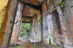
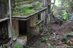
In 1942 most of the mine was moved two kilometers to the south, to the present location, where a sifting plant with a capacity of 100 tons per month was built. In 1957 the sifting plant was expanded to 200 tons per month, but around six years later the plant stopped to be profitable due to cheap ore from overseas when trade liberations kicked in – the unexpectedly low quality of the ore at the new deposit didn’t help either and so the mine closed in 1965.
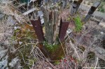
At its zenith about 1,500 people worked at the Tsuchikura Mine, sadly there is nothing left of the mining town surrounding it. All there is to see today is a couple of concrete constructions on a steep slope and a roofless house towards the top of it – probably the previously mentioned sifting plant, once wainscoted by wooden buildings. (If you are interested in some old photos please *click here* – the text there is in Japanese as this is the first time somebody writes a bit more about the Tsuchikura Mine in English on the internet.)
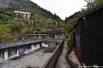
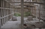
Exploring the abandoned leftovers of the Tsuchikura Mine was pretty easy thanks to its popularity. The place consisted of several “floors” with concrete fluid reservoirs and brackets for conveyer belts which looked a bit like Stonehenge. Since quite a lot of people seek to get up there nice explorers installed ladders and lots of ropes. People in decent shape and free from giddiness should have no problems to make it up the slope and enjoy a nice view down on the remains and the rather narrow valley. In comparison to the *White Stone Mine* and even the *Iimori Mine* the Tsuchikura Mine was rather boring, but it offered some nice angles and interesting views to take pictures of – and if you are lucky you will meet a photographer and their cosplay models… (Abandoned mines are popular amongst certain niche photographers. You know, production value!)
(If you don’t want to miss the latest article you can *follow Abandoned Kansai on Twitter* and *like this blog on Facebook* – and of course there is the*video channel on Youtube*…)
Pretty much a year ago, a couple of weeks after we explored the *Love Hotel Gion* and the *Biwako Tower & Igosu 108* together, I met up again with my haikyo buddies Andrew and Damon. Our goal was a mine in the mountains on the border between Shiga and Gifu, but we got distracted pretty quickly.
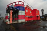
Andrew was driving along the highway when Damon spotted a big red building that looked abandoned. We turned around only to find out that the place was not only abandoned, but a pachinko parlor. 2 months prior, while on the road with Jordy, I was able to explore an example of this oh so typically Japanese kind of entertainment location in Shikoku called *Big Mountain Pachinko Parlor* – this time we stumbled across the abandoned K-1 Pachinko Parlor.
While entering Big Mountain was a piece of cake it took us a while longer to enter K-1, but after a couple of minutes we found a way in. Against all odds and to our total surprise K-1 was in similar good shape as Big Mountain. Usually abandoned pachinko parlors are boarded up and / or looted and / or vandalized. K-1 showed some signs of all three factors, but none of them to a point where it hurt the atmosphere severely. When I wrote about Big Mountain I wrote quite a bit about pachinko in Japan in general (and its importance for North Korea), so if you are interested in that kind of background information then *please look here*.
While Jordy and I were in quite a hurry and squeezed Big Mountain between the hotel *shangri-la* and the *F# Elementary School* Andrew, Damon and I were able to took our time – this time we were even able to explore the upper floor Jordy and I missed in Tokushima. Coming up the stairs I found something that made me laugh out loud: Next to a page from a Japanese porn magazine lied a gripper – you gotta love the local humor! (Or was it North Korean humor? Who knows…)
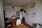
The first room we entered upstairs was the main office / surveillance room. Three big monitors once hooked up to security cameras were still in place, and so was the big safe. Business cards, prizes, furniture and other stuff were scattered all over the floor, making the room quite a mess. The kitchen across the hallway on the other side was in pretty immaculate condition and looked like it was just left the other day. I’m not exactly sure when the K-1 Pachinko Parlor was closed, but judging by the calendars and train schedules on the walls it must have been around summer 2003. (Outside on the building was still a big sign from a real estate company trying to sell the thing – if you want me to make contact for you let me know!)
The hallway itself was pretty cluttered, too. We found some pretty big shoes and lots of porn, magazines as well as videos, in one of cabinets. What is it with porn in abandoned buildings? There seems to be a mysterious connection…
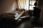
Most of the other rooms on the upper floor were actually living rooms / bed rooms. Some of them looked like they were ready to use, others not so much. One of them was stuffed with countless pachinko machines and spare parts. Also worth mentioning was the relaxing area out on the flat roof. There we found a couch, a table and a TV outside. Since it was snowing I’m sure all items were useless at that point, but I could clearly imagine some exhausted pachinko parlor employees far away from home sitting outside after a tough day of work, chilling with a chilled beer, enjoying their off-hours on a nice spring or autumn evening; you know, living the life!
Before we left heading for the mine we explored a small building across the parking lot of the K-1 Pachinko Parlor. In my article about Big Mountain I explained how the pachinko balls people win are exchanged for prizes since gambling is rather strictly regulated in Japan. Those prizes usually are getting off at “pawn shops” near the pachinko parlor – and the building on the parking lot most likely was one of those pawn shops. It was accessible, but completely gutted and therefore totally unspectacular. Nevertheless it was nice to have seen one of those shops, just to make the experience complete…
*Nara Dreamland* is the current haikyo hot spot in Kansai, maybe in all of Japan. But the area including Osaka, Nara, Kyoto and Kobe is also the home of a classic urbex location: the Maya Tourist Hotel. (A.k.a. Maya Kanko Hotel, Mayakan, Mount Maya Hotel, Mount Maya Onsen Hotel, and Gunkan Hotel – Battleship Hotel / Warship Hotel; similar to *Gunkanjima*, the now also abandoned Battleship Island off the coast of Nagasaki.)
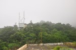
Mount Maya is one of the highest peaks of the Rokko Mountain Range that spreads from the west end of Kobe to Takarazuka (near Osaka) and is one of the most popular recreational areas in Kansai. In 646 the Tenjo-ji (忉利天上寺), a Buddhist temple, was founded near the top of the mountain at the behest of Emperor Kotoku. During the 8th century a monk named Kobo brought a statue from China to the temple – a depiction of Maya, Buddha’s mother; and that’s how the Mount Maya got its name. (The original temple was burned to the ground by a pyromaniac in 1975. The remains are still a popular destination for hikers, although the temple was reestablished further north and at a higher place.)
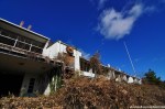
The Maya Tourist Hotel is located halfway up the mountain and in walking distance of the original Tenjo-ji. It should be obvious how the place got its name… Something I still haven’t figured out is why it took me almost a year to go to the Maya Hotel and another 17 months to write about it, although the hotel is basically in my backyard, just a couple of minutes down the rail on a single line (yes, no need to switch trains!).
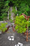
Going to the Maya Hotel was actually my first exploration I haven’t done by myself or with a friend, but with a fellow urban explorer: Michael Gakuran. Mike was passing through the area on his way back home from a summer trip to the Seto Inland Sea and asked if I was interested in a joint adventure – and since he runs one of few blogs I actually read it was a pleasure to say yes. Michael likes his abandoned places rather high profile (who can blame him for that?) and so we pretty quickly narrowed it down to the Maya Hotel. The downside of that location: It’s right next to an active cable car station whose employees have a reputation for calling the police if they see trespassers on their way to or on the premises of the Maya Hotel (you have a beautiful view at the roof of the hotel from the cable car station). Since Mike and I are both rather dedicated explorers we decided to tackle the place hardcore style: During my research about the place I found out that there was a steep closed hiking trail up the mountain that leads there without getting close to the cable car station. To be able to take some photos on the rooftop we met at a Hankyu line station before 5.30 in the morning, hiked about 400 meters up the insanely steep, spider web covered abandoned hiking trail to finally reach the hotel; drenched in sweat and out of breath. Osaka / Kobe summers are everything but nice, the temperature barely ever falls below 30 degrees Celsius (even at night!) and the humidity is breathtaking. Especially in the morning, especially hiking up a forest trail, especially close to an abandoned and rotting hotel. Getting up Mount Maya that morning was my worst hiking experience without getting in physical danger and the third worst overall. Oh, and did I mention that I’m not a fan of alarm clocks at 4.30 in the morning? They tend to make me grumpy…
Luckily the anticipation of exploring a legendary abandoned building dominated over my morning grouchiness and so Michael and I reached the Maya Hotel in good spirits. Until we reached the entrance. Which was recently boarded up and ripped apart again. Carefully we got closer, gigantic flying insects the size of table tennis balls buzzing around and landing on us. Footsteps inside. 100%! What should we do? Getting inside? Waiting to be eaten alive by the insects? After a short deliberation we decided it would be better to take our chances with whoever was inside than with the nasty beasts outside, so we passed through the cracked open plywood and entered undaunted by death – only to find out that the footstep noises were created by dripping water. Of course we weren’t convinced right away, but after 5 minutes… well, 10 – okay, after 15 minutes we were confident that we were alone in the big hotel.
The history of the Maya Hotel started in 1929. Four years after the Maya Cable Car (officially Maya Cable Line (摩耶ケーブル線, Maya Kēburu-sen) began to transport tourists to the foot of Tenjo-ji the same company decided it would be a good idea to have a hotel up there – so they built it right next to the upper terminus. Construction began on May 15th 1929 and the Maya Tourist Hotel opened after a record time of just 6 months on November 16th. 15 years later, late in World War 2 on February 11th 1944, the Maya Cable Car was shut down as a non-essential line and the next year the hotel was forced to close, too. I’m not sure though if it was before or after the damages through air raids occurred – on top of Mount Maya were anti-aircraft guns installed and I guess taking them out damaged the hotel. Shortly after the war plans to turn the hotel into an officer’s club for the U.S. Forces fell through. In 1960 the cable car company decided to sell the severely damaged hotel and the new owner began renovations on September 1st. On August 28th 1961 the once so luxurious lodging was renovated to shine in new splendor – with parts from the French luxury ocean liner “SS Île de France” which was disassembled in the spring of 1959 in Osaka. But the grand re-opening wasn’t followed by a streak of good luck and so the Maya Tourist Hotel was forced to close its doors again in 1967, this time after suffering severe damages from a typhoon and a resulting mudslide. A final and finally rather long-term future began in 1974 when the place was re-opened again as the “Maya Student Center”. But the student center was closed in 1994 and the destiny of the Maya Hotel was sealed on January 17th 1995 when it suffered severe damage from the Great Hanshin Earthquake that killed almost 6.500 people – in the aftermath the construction was boarded up and fenced off, and its rise to become one of the most famous abandoned places (haikyo) in Japan began.
Since time was of the essence when Michael and I arrived at the more than 80 years old Maya Hotel we went right to the rooftop to take some photos outside before the crew of the cable car station would appear for work. The atmosphere was utterly eerie. Half of the mountain was covered by low hanging clouds, so at first our sight was quite limited while the sun tried to break through. I felt like in the middle of a horror film, but at the same time I knew there was an active cable car station just a stone’s throw away. A weird, slightly surreal situation. The chimney on the top of the roof collapsed a couple of years ago and was lying there like a gigantic crumbling grey cigar. Crushed through a lower roof on the southern side I saw the famous plane tire that once actually stuck in the roof. (Nobody seems to know where the tire is from and when it got onto, or better: into, the roof. It’s the tire of a B-29 Superfortress though – used in WW2 and retired in 1960.) The tranquility of the place was amazing, totally worth getting up at a time people should rather go to bed and climbing up a mountain at the worst time of the year. Sadly we had to hurry since 8 a.m., our personal roof deadline, came closer – the cable car started at 8.30 a.m. and we wanted to be out of sight with a little bit of a buffer. Only minutes after we got back inside of the Maya Tourist Hotel we heard a sound signal from the cable car station.
Exploring the inside of the Maya Hotel was almost as exciting as exploring the outside. Since the place was abandoned almost two decades ago with little renovation in the years before, there were only a few pieces of furniture left, the most striking one a red leather couch clearly not part of the original inventory As far as I know it was part of a video shooting – at least three Japanese bands used the abandoned hotel as a location for their music videos. Not to mention the countless photo shoots. Urbex, fashion, nudes – its stunning architecture made the Maya Hotel one of the most photographed modern ruins in Japan, probably in the world. Luckily most visitors carry a tremendous amount of respect for the place, so vandalism is a surprisingly minor factor. I guess when you deal with the hassle of getting to the Maya Tourist Hotel without being discovered you rather enjoy the breathtaking theater hall, the beautiful dining room and all the big and little surprises waiting for curious and careful explorers. And you have to be careful visiting the Maya Hotel! Water is running down the walls and dripping from the ceilings, broken stuff is lying around everywhere and the floors are severely damaged. Nevertheless the Maya Hotel as a whole is stunningly beautiful, magical, just fascinating. Nowadays most abandoned hotels get trashed before they get the chance to age properly – the Maya Hotel was abandoned several times and the 1920s architecture offers a completely different basis than the usual concrete blocks that look like they were designed by the same architect and interior designer.
Now I have to bring this pretty long article to an end somehow; maybe by linking to nk8513’s blog, you can find his collection of old photos and leaflets *here* (it’s in Japanese, but even if you go there just for the picture material you won’t regret it). Well, other than that let me say that this was my last exploration before I got a wide angle lens and a tripod, so the photos are not nearly as spectacular as I hoped they would turn out to be – considering the age of this blog it’s actually quite old material. I hope the three videos will make up for it a little bit… Oh, and thanks for reading till the very end!
(If you don’t want to miss the latest article you can *follow Abandoned Kansai on Twitter* and *like this blog on Facebook* – and of course there is the*video channel on Youtube*…)
The White Stone Mine (also known as the White Limestone Mine, the Fujiwara Mine, and the Shiraishi Mine – I guess it can be read Shiroishi Mine, too…) is one of the most famous abandoned places / haikyo in Japan. For years people seemed to be quite vague about its location, but ever since GoogleMaps offers high-res satellite photos of the area pretty much everyone can confirm the whereabouts after a bit of research – when I first heard about the White Stone Mine 2 years ago all I saw was a greenish brown mush 4 hours away by train, plus another 70 to 80 minutes by foot. Not worth the hassle, especially since I had many 100% confirmed places rather close-by back then. And I was still an urbex noob after all. In autumn of 2010, almost a year after my discovery, Michael Gakuran told me that he wanted to revisit the mine with some friends of his and asked me if I wanted to tag along. Michael and I met twice before for some explorations and it was always great fun, so I didn’t hesitate a second to join the small group.
When I started me trip to the middle of nowhere the weather was great – sunny, 15 degrees Celsius, a nice autumn day. When I arrived at the train station to meet Michael and his friends, a couple of stations before the terminal stop, the weather was still nice. Then we drove towards the mountains and all of a sudden the weather turned. Cloudy… grey clouds… When we finally reached the mine at around 12.30 (traffic can be a trial of patience in Japan…) it started to drizzle – of course I didn’t bring an umbrella. But well, after almost 6 hours I was standing in front of the biggest mine I’ve ever been to and I was looking forward to finally take some photos.
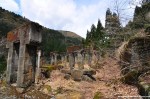
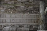
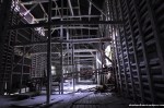
The White Stone Mine is gigantic! Close to three dozen buildings spread across an area of about 500 x 100 meters. Despite its size there is not much known about the Shiraishi Mine. It was founded by two brothers in 1921 and mining ended in 1969, supposedly after severe damage from a typhoon; the last office on the premises shut down in 1974. But the White Stone Mine was not only a limestone mine, it was also a huge chemical plant with facilities to extract calcium carbonate – a very important base substance for the paper industry. I guess in Japan calcium carbonate is mostly used for construction materials (especially cement), but also for the purification of iron in a blast furnace (at least when the White Stone Mine was still in business). Japan’s cement industry is actually huge – Japan still is the #5 consumer, #4 producer and #3 exporter of cement in the world. Japan’s coast line is famous for its sheer endless amount of concrete tripods and when you go hiking you can see surprisingly many concrete roads in the middle of nowhere – it seems like politics and the cement industry are heavily intertwined…
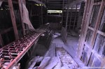
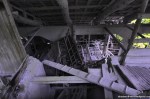
Exploring the White Stone Mine was exciting, sadly we were running out of time quickly. The sun goes down early in Japan, especially on a late October day in the mountains, even more so when it’s raining. Michael was a great experienced guide who was able to point out some of the best and the worst spots of the gigantic area quickly. An area I saw maybe 30% of. Although the mine was abandoned about 40 years ago it seems like there’s still somebody taking care of the premises: Michael pointed out differences to what he saw half a year prior (tarps covering wooden buildings here, new “Keep out!” signs there…) Although we kind of rushed through the lower area of the mine it already got dark by the time we reached the big silos up the slope. When we got back to the car it was already pitch-black outside and raining heavily. Nevertheless it was a great trip and totally worth the long train ride. A train ride I have to do again one day to explore the other 70% of that gorgeous mine… To be honest, I think it will take at least a full day to explore the whole area, maybe two or three days to shoot the whole mine properly. I doubt I’ll have time for that, but the White Stone Mine is definitely one of the few places I would really like to revisit! Even for (half) a day…
(If you don’t want to miss the latest article you can *follow Abandoned Kansai on Twitter* and *like this blog on Facebook* – and of course there is the*video channel on Youtube*…)
Haikyo HDR photos or not… that was a big questions two years ago.
From the start I wanted to keep Abandoned Kansai simple. A blog instead of a homepage, photos directly out of the camera instead of massive post production – resize to 1024*680, URL in the lower right corner. That’s it. No cropping, not filters, no nothing. I actually shoot in JPG, for almost two years not even in the highest resolution. All the photos published on Abandoned Kansai are done that way. After some positive comments I started to take a few photos in NEF, just in case; maybe 2 or 3%, not one of them I ever opened. When I got a tripod, I started to use the bracket function of my D90 at maybe every fifth location – again just in case. After a while I played around with a freeware HDR program, just for fun. While I like the aesthetics of tone-mapped HDR photos I still consider them mostly a gimmick. Nevertheless I decided to publish some of my experiments – below are two samples, *for more haikyo HDR photos please click here*.
(Updates will be announced on *Twitter* and *Facebook*, not on the main page.)
Nippon No Haikyo, probably the most famous Japanese book about urban exploration / haikyo since it was recommended plenty of times by both Japanese and foreign blogs because of its huge amount of maps, recommended Yashima as one of the top abandoned places in West Japan. In my opinion Nippon No Haikyo is vastly overrated – while some maps are quite detailed others are completely useless. Even more so since an estimated 50% of the places (at least on the West Japan list) are either demolished or completely trashed by now. At the same time some of the best haikyo locations, like *Nara Dreamland*, are missing completely. But I guess you’ll get what you pay for: a 4 year old book about a topic that can change within a week or two. Especially in Japan, where old buildings are replaced by parking lots while you are on vacation. (It actually happened in my neighborhood…)
So whenever I visit a location described in Nippon No Haikyo I’m prepared for the worst, just in case. Which was a good thing in the case of Yashima – more than half of the buildings that were responsible for the praisal are gone now; four, to be specific. All that was left of them: 3 leveled building grounds, ready for new construction to begin. Construction that most likely won’t happen.
Yashima (屋島, roof island) has attracted people for centuries. The famous temple Yashima-ji on top of the mountain, founded as a Ritsu school temple in 754 by Ganjin (a.k.a. Jianzhen, 688–763), is the 84th stop of the Shikoku 88 temple pilgrimage. On March 22nd 1185 the Battle of Yashima took place in the waters around Yashima, resulting in one more defeat for the Taira, who owned a castle on top of the mountain. (Which is being reconstructed as I write these lines…) The whole story was later made popular in an epic poem called “The Tale of the Heike” (平家物語, Heike Monogatari).
A famous temple, stunning views of the Seto Inland Sea, a historical battle. What else do you need to attract tourists? Right, an aquarium! The Yashima Mountaintop Aquarium (屋島山上水族館, Yashima Sanjo Suizokukan) was opened in 1969 and reopened as the New Yashima Aquarium (新屋島水族館, Shin Yashima Suizokukan) in 2006. In-between some (not so) smart businessmen took advantage of the Japanese asset price bubble (1986 to 1991) to build some rather big hotels on Yashima, creating way more beds on the 300 meter high mountain than necessary. Because let’s be honest: Yashima is a daytrip location, not a place to stay overnight. (Heck, I made it a daytrip although I live in Osaka!) Around the turn of the millennium most of those new hotels were already forced to close, only a few smaller ryokan north of Yashima Temple survived. It seems like the closed hotels were still standing there when Nippon No Haikyo was written in 2007, maybe for two or three more years – when I visited in late 2011 most of them were gone… The Lost Ruins of Mount Yashima.
(I used this posting for a big update of my *Map of Demolished Places in Japan* – it’s really worth a look!)
The now abandoned Sembach Air Base has quite a long history. The location was first used as an airfield after World War I by the French occupation troops in 1919 with 10 sheet-iron barracks and 26 wooden hangars. When France retreated from Germany in 1930 the air base was abandoned on June 15th and the land was returned to farmers who used it as a hay field. (The area around Sembach is very rural and agriculture is an important economic factor till this very day.)
In preparation of World War II the Nazi-German Luftwaffe deemed the area proper to build a fighter base and claimed the land in early 1940, but gave it back to the owners in June of 1940 after France was conquered in a blitzkrieg now known as the “Battle of France”.
After the defeat of Nazi-Germany in May of 1945 Sembach was part of the French occupational zone. In April of 1951 German surveyors along with French officers were looking for suitable locations for air bases. The Cold War had begun a few years prior and both the NATO and the Warsaw Pact armed themselves at a remarkable speed. The NATO’s lack of air fields suitable for modern jets made it necessary to build new military airports – so the French authorities began with the construction of a hard surface airfield in June of 1951, much to the protest of local farmers, who demonstrated in Mainz, the capital of Rhineland-Palatinate, without much success. On September 1st the United States took over the construction site, naming it Sembach Air Auxiliary Field, and pushed hard to finish the base – completing the 8500 foot concrete runway by the end of the month working round the clock using nighttime illumination. The rest of the airfield (tower, hangars, repair shops, storages and other buildings) were built during the winter. Local protests rose again when plans for the construction of barracks and office buildings surfaced in April of 1952 – this time with a little bit more success: Instead of using valuable farm land the new buildings were constructed on a sandy area with little agricultural value about 1.5 kilometers away from the airfield (Heuberg). Everybody was happy and after another year of construction the American flag was finally raised at the base now known as Sembach Air Base on July 8th 1953, when a RB-26 Invader arrived from Shaw Air Force Base in South Carolina. It was part of the 66th Tactical Reconnaissance Wing, the first of many units to be stationed in Sembach.
40 years after Sembach Air Base was opened protests rose again – this time because the Americans announced plans that the base will only be used as a substation of Ramstein Air Base; a huge economical setback for the town and nearby cities, directly (German civilian employees at the base) and indirectly (soldiers spending money in the area). The airfield was returned to German control two years later on March 30th 1995, the installations in Heuberg were renamed Sembach Annex. In summer of 1998 the demolition of the base began, the runway being the first “victim” of this process. Since then most of the buildings on the former air base have been demolished – but not all of them, at least not by the time Gil and I arrived at the location.
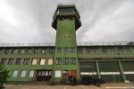
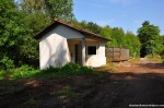
After the *Deportation Prison Birkhausen* and the *USAREUR Communication Facility Lohnsfeld* turned out to be quick stops we decided to tackle another big one and drove to Sembach to have a look at what was left of the air base. First we went to the western part and found some half-underground bunkers, inaccessible of course. Next was a small office building (?) that looked like it was made of corrugated cardboard. Quite interesting was the former Fire Station, part of the Fire and Emergency Service. I was rather surprised by the coloring of the toilets – white and pink. Seriously? The restrooms of the fire department on a US Air Force base were pink?
In the afternoon, when we left the fire station, the weather started to turn drastically. The sunshine was gone and dark grey clouds approached quickly. While we were making our way to the abandoned tower the wind sped up massively – to my favor as I should find out minutes later. I just finished shooting the tower building when a wall of rain came closer quickly and before I had the chance to take shelter it poured liked I was standing in the shower; a first class cloudburst. At that time I was close to the eastern wall of the tower, so I pressed myself against the high wall while the wind was blowing so hard that it actually blew the rain over my head. About 15 minutes I was standing there, hoping for the wind to continue and the rain to stop. When the heavy rain turned into light drizzling I started to look for Gil, who found shelter in a nearby building I assumed was inaccessible. That building was boarded up (almost) completely and its massive walls made me wonder right away what it was used for. Sadly it was pretty much empty, nevertheless we found some interesting items – a sleeping bag and other signs of a homeless person being there for a while, a perforated cardboard character and some documents with rather sensitive information; like special travel orders, granting individuals the permission to hand-carry a M16 rifle. I have no clue how those documents escaped the shredder, but I guess I better refrain from posting photos since each sheet of paper contained several names including ranks and addresses…
Going on an exploration trip with Gil was absolutely fantastic (thanks, man!). While the first two locations were quite disappointing from an urbex point of view Sembach Air Base made up for it big time. It was the first US military base I was able to explore (yes, I went to a second one, so stayed tuned!) and I had a blast – no pun intended. The locations in Germany differ quite a bit from the places I usually get to see in Japan, so I really enjoyed this refreshing experience!
Urbex in France? Urbex in Luxembourg? Urbex in Belgium? Or urbex in Germany? That was the big question after our visit to the *Deportation Prison Birkhausen* was a unexpectedly short one – where should we continue our urban exploration day trip? There were plenty of options, but since Kaiserslautern (a.k.a. K-Town, especially amongst American military) was rather close we decided to continue our explorations there. The next place to visit: The USAREUR Communication Facility Lohnsfeld.
Very little is know about this former US military installment. The Energy Engineering Analysis Programm (EEAP) from August 1986 prepared for the Department of the Army, European Division, Corps of Engineers described it as “Located at Lohnsfeld, the station consists of a barracks and receiver building”. The facility was open from at least 1953 and on 1998-09-03 the U.S. Department of Defense announced that the Lohnsfeld Communications Station will be returned to the host nation, in this case Germany. It seems like my home country didn’t have any use for it and left the comm fac in the middle of nowhere abandoned, until… it was demolished in October of 2007. Which I found out about after I went there with my old buddy Gil – after we drove through the middle of nowhere for maybe half an hour, including dirt roads along some fields and an airport for model aircrafts. So maybe urbex in France, urbex in Luxembourg or even urbex in Belgium would have been a better alternative. (The place I really wanted to go, Villa Viktoriastift, one of the few abandoned mansions in Germany, became inaccessible a week prior when the new owner of the place was fed up by geocachers swarming the place – so he informed the police, threatened to sue some people (including the person who put the cache there!) and hired security…) Luckily Lohnsfeld wasn’t our last stop on our trip to Palatinate – and the last location made up big time to the first two less successful ones…
The first time I heard about the abandoned deportation prison Birkhausen in the forest near Zweibrücken-Ixhausen, within a stone’s throw from The Style Outlets mall and Zweibrücken Airport, I got really excited. Abandoned prisons are rare… but an abandoned deportation prison? I’ve never heard of a place like that before! Even better: Zweibrücken was in rather close proximity of where I was staying during my yearly vacation to Germany, so I could easily get there by car in about 90 minutes – after I had to wait about 8 month to visit family and friends back home gain…
I met my old friend Gil at a high school reunion and we talked about urbex – he just failed entering an abandoned mill (the huge, early industrial kind from the late 19th century) due to lots of nosy neighbors and the place being boarded up, so I suggested to go on an urbex trip together. I guess it’s no suprise we decided to break into the prison! (And by “break in” I mean “enter through an open door or window” – I’ve never broke or even destroyed anything to access an urbex location and I never will! Vandalism isn’t my thing…)
The history of the prison in Birkhausen was short: The premises were used for decades to house a day-parole building with a market garden and a tree nursery (as a branch of the correctional facility Zweibrücken) before the buildings were converted into a deportation prison in 1996. About 900 people obliged to leave Germany passed through the facilty each year before it was closed in 2005 – from now on Ingelheim was the only deportation prison in Rhineland-Palatinate (no, dear Star Wars fans, not Palpatine…). Instead of demolishing the prison the Justice Department decided to keep it, considering plans to turn it into a prison for senior citizens.
When Gil and I walked along a forest road a truck with an empty construction waste container passed us by – and our hearts sank. A couple of minutes later we had certainty that the prison was in the process of being demolished. We approached the (de)contruction workers and they waved us through to their foremen. As always in situations like that honesty is the way to go, so I explained them what I am doing as a hobby and that I came to take pictures of the prison. The guys were really nice, but blocked right from the beginning – no photos, not without permission from the authorities; which would take way too long even if we could get it since they were about to finish they job by the end of the week. I asked them why the prison was taken down and they told us that geocachers were swarming the place ever since a cache was hidden there (later I found out the cache had almost 1400 logs on geocaching.com alone!) – all of a sudden the prison was kind of famous and irresponsible people brought their whole families, not even thinking about the dangers a place like that would hold. So the State decided to tear it down. So I explained that I have nothing to do with geocaching – urban exploration is about taking nothing but pictures and leaving nothing but footprints, about keeping places secret (unless they were demolished or turned into tourist attractions…). My reason to come here was to take some nice photos to keep the memory about the place alive. The older guy started thinking and said that he wanted to take pictures himself, but never had the chance since they were so fast tearing everything down – so he asked his younger colleague to stay with us while we took some quick shots to prove that the place was gone and to spread the word about it; but no pictures of people or equipment! Gil and I happily agreed and had about five minutes to take some quick shots. All of a sudden the foremen’s boss showed up, so the two guys gave us a sign and we took our equipment to head towards the exit – quickly greeting the boss while hurrying away…
Leaving the deportation prison I was devastated at first. Such a great location gone because it grew to popular – not even amongst urban explorers, but amongst geocachers! Such a shame… (To be fair: Another reason to demolish the place might have been the serious amount of vandalism – and on 2009-08-24 there was a case of arson that burned down half a building. Where those vandals came from? I have no idea, but the cache called Alcatraz was hidden back in 2006…) At least Gil and I were able to take some photos due to our successful conversation with the demolition squad – unique pictures I might add since altogether it took them about 3 weeks to get rid of the whole facility and I don’t think they gave permission to photographers before…